

Кошик:
0
товар
Товари
(порожній)
Немає товарів
Має бути визначеним
Доставка
0,00 €
ПДВ
0,00 €
Всього:
Ціни з ПДВ
Товар успішно додано до Вашого кошика
Кількість
Всього:
0 товарів у кошику.
1 товар у кошику.
Всього товарів на суму:
(з ПДВ)
Загальна вартість доставки: (з ПДВ)
Має бути визначеним
ПДВ
0,00 €
Всього:
(з ПДВ)


Інформація
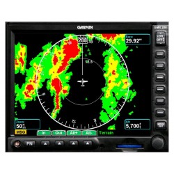
Features
- Multi Function Display built around the design of the MX 20
- Bright, high resolution display depicting position awareness, weather, traffic, terrain, charts, and more
- Soft keys allow pilot to select between several charting options and easily add or remove details
- Rotary knob allows for quicker map scale changes and data entry
- Faster processing speed - 650 Mhz / 256 MB
- Front loading SD card slot allows for expanded memory and easy chart uploading and updating
- Includes preloaded, high-resolution terrain and hydrography data for entire world
- Map scale range from 1/4 mile to 2500 miles
- Split screen function allows for simultaneous view of two charting options along with vertical profile of terrain elevation
- Optional chartView feature can be added for airport and terminal information
- May be interfaced to Garmin equipment such as GNS 430 / GNS 530 for GPS position, GDL 69 / GDL 69A / GDL 90 for Datalink, GTX 330 /33 for Traffic, GWX 68 for Radar
- Radar version also compatible with Bendix/King ART-2000, ART-2100, and RS-181A radar sensors
- Will interface to many other manufacturers' GPS navigation equipment (list forthcoming)
- Available in 3 versions: Standard, Traffic, and Radar/Traffic
- 5 RS-232 ports (1 needed for GPS and altitude; 4 left for other interfaces)
- Standard System includes installation kit, rack, datacard, and manuals
- New rack design offers more installation versatility compared to MX 20
- Different shape than MX20 but has same dimensions
- Improved cooling configuration
- Upgrading from MX20 involves unscrewing connectors from MX20 rack, checking power (pins 1 & 16) and ground pins (2 & 12), adding APM (3 new pins on 37 pin connector, installing GMX200 rack, attaching connectors, and configuring GMX200